CINDI Science Team Member, Dr. Greg Earle, demonstrates how electric and magnetic fields affect flowing electrons with a “Complete e/m system” from Pasco.
Virtual Lab/Instrument Tour
CINDI Science Team Member Dr. Greg Earle gives a virtual tour of mockups of the ion drift meter in the actual UT Dallas Space Science Center laboratory where the CINDI instruments were built.
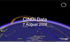
Watch a movie of CINDI data made with Google EarthTM. Actual Data from CINDI is presented with Google Earth, allowing for flows of ions and neutrals to be seen in an orbit to-scale with the planet. Yellow denotes daytime. Blue denotes nighttime.
The Read Me file contains explanations on what the data represents and how the movie was put together. The Google Earth File from which the movie was created is also available.
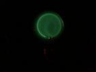
A time lapse video of actual plasma bubbles as a function of altitude as seen by radar reflections from a radio telescope.
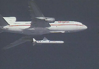
The C/NOFS spacecraft carrying CINDI was launched not from the Earth's surface, but from the bottom of a plane. Although the C/NOFS launch was at night, we have a movie of a launch system in action, along with other ideas for discussing rockets in the classroom on the Rocket Page.
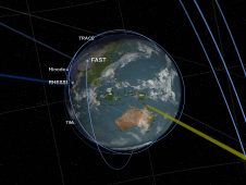
Sentinels of the Heliosphere is an excellent resource for exploring the variety of orbits for NASA's Sun-Earth observing fleet, the shape of the magnetosphere, and more. The creators describe the visualization as one that "tours the regions of near-Earth orbit; the Earth's magnetosphere, sometimes called geospace; the region between the Earth and the Sun; and finally out beyond Pluto, where Voyager 1 and 2 are exploring the boundary between the Sun and the rest of our Milky Way galaxy. Along the way, we see these regions patrolled by a fleet of satellites that make up NASA's Heliophysics Observatory Telescopes. Many of these spacecraft do not take images in the conventional sense but record fields, particle energies and fluxes in situ. Many of these missions are operated in conjunction with international partners, such as the European Space Agency (ESA) and the Japanese Space Agency (JAXA). The Earth and distances are to scale. Larger objects are used to represent the satellites and other planets for clarity."